I was on an evening hike today at my local spot and came upon a beautiful Southern Pacific Rattlesnake.
Hello up there!
Being warned not to come any closer.
Is that a lump in your belly? See ya later.
Snake list for Calavera Preserve: 4 Southern Pacific Rattlesnakes, 1 Red Diamond Rattlesnake, 3 Striped Racers, and 1 San Diego Gopher Snake.
When we try to pick out anything by itself, we find it hitched to everything else in the universe - John Muir
Tuesday, August 27, 2013
Thursday, August 22, 2013
Mono Lake
Sunday, we spent the day exploring the Mono Lake area. This lake, with no outlet, is notable for many reasons.
Mono Lake is two and a half times saltier than the oceans. For many years, Los Angeles was diverting the streams that fed into the lake, causing the level to drop. The lake lost about half its volume. Legislation in 1994 set a goal of maintaining a minimum level. That is a lightning caused fire in the background.
Tufa towers are mineral deposits caused by underwater springs. They are now exposed from the dropping of the water level.
These are brine shrimp. No fish can live in the water, but the lake is a vast supply of brine shrimp and alkali flies - important food sources for migratory birds.
Not only birds eat the flies; the Native Americans, the Kutzadia'a, collected the fly pupae and used them as one of their main food sources.
Here a California Gull runs and scoops flies with its mouth open. Mono Lake is the exclusive nesting
site of the California Gull.
A tufa dinosaur?
Some of the tufa towers are 30 feet high and had osprey and osprey nests on them.
Gail scale.
Craters surround three sides of Mono Lake. The ones on the south side form the youngest mountain range in North America.
The gnarled remains of a small tree on Panum Crater. We took the trail up and around the rim of Panum Crater, which erupted 640 years ago.
The core of the crater has toppled pinnacles of obsidian.
The obsidian had alternating bands of pumice - a rock so light, that it floats.
The trail around the inside rim of Panum Crater.
Driving back out from the crater.
Flowers make us smile!
This mobile in the visitor center is of Wilson's Phalaropes which are one of the many species of birds that depend on Mono Lake during their migrations. These little birds fly for 72 hours without stopping as they cross a big section of the Pacific Ocean to get to South America.
In a coffee shop Gail spotted this centipede (?) .
This is not a picture of Hurricane Sandy, but is indeed our motel room. Never stay at the Mammoth Lakes Motel 6 if you can help it.
Heading south the next morning, we passed "Brown's Town", a really cute, clean, RV / camping park with golf course. It was a trove of antiques and local history.
Further south on 395 is the Japanese internment camp of Manzanar. There used to be 8 guard towers like this one with machine guns aimed inwards at Japanese Americans being held during WWII. The big building was the gym, and is now a museum / visitor center.
As we passed through Lone Pine, we could see Mt. Whitney, at 14,550 feet, it is the tallest mountain in the Lower 48.
This is a motel room, Route 66 style.
The motel office. Well, that concludes the story of our trip to the east side of the Sierras. I apologize for all the pictures - we started with 288.
Mono Lake is two and a half times saltier than the oceans. For many years, Los Angeles was diverting the streams that fed into the lake, causing the level to drop. The lake lost about half its volume. Legislation in 1994 set a goal of maintaining a minimum level. That is a lightning caused fire in the background.
Tufa towers are mineral deposits caused by underwater springs. They are now exposed from the dropping of the water level.
These are brine shrimp. No fish can live in the water, but the lake is a vast supply of brine shrimp and alkali flies - important food sources for migratory birds.
site of the California Gull.
A tufa dinosaur?
Some of the tufa towers are 30 feet high and had osprey and osprey nests on them.
Gail scale.
Craters surround three sides of Mono Lake. The ones on the south side form the youngest mountain range in North America.
The gnarled remains of a small tree on Panum Crater. We took the trail up and around the rim of Panum Crater, which erupted 640 years ago.
The core of the crater has toppled pinnacles of obsidian.
The obsidian had alternating bands of pumice - a rock so light, that it floats.
The trail around the inside rim of Panum Crater.
Driving back out from the crater.
Flowers make us smile!
This mobile in the visitor center is of Wilson's Phalaropes which are one of the many species of birds that depend on Mono Lake during their migrations. These little birds fly for 72 hours without stopping as they cross a big section of the Pacific Ocean to get to South America.
In a coffee shop Gail spotted this centipede (?) .
This is not a picture of Hurricane Sandy, but is indeed our motel room. Never stay at the Mammoth Lakes Motel 6 if you can help it.
Heading south the next morning, we passed "Brown's Town", a really cute, clean, RV / camping park with golf course. It was a trove of antiques and local history.
Further south on 395 is the Japanese internment camp of Manzanar. There used to be 8 guard towers like this one with machine guns aimed inwards at Japanese Americans being held during WWII. The big building was the gym, and is now a museum / visitor center.
This is a motel room, Route 66 style.
The motel office. Well, that concludes the story of our trip to the east side of the Sierras. I apologize for all the pictures - we started with 288.
Wednesday, August 21, 2013
Backpack to Pioneer Lakes Basin
Last week, Gail and I drove to Bishop, CA, on the eastern side of the Sierras where we met my cousin Sue and her partner Paul. Paul had cooked up the trip, and lucky for us, invited us along.
Bishop is an eclectic town of cowboys, sportsmen, and mountaineers. We liked the bluntness of the restaurant sign.
The crew: me, Gail, River, Tim, Sue, and Paul. Tim and River joined us for the first night, and then returned to Bishop the next morning. Paul and Tim met as SAR (search and rescue) team members a number of years ago. We heard great stories in the evening about SAR adventures, including the discovery of Steve Fossett's remains. River was one of the nicest 9 year olds you could ever meet!
Ruby Lake was where we camped for the first night.
Our tent site, nestled among the trees and rocks. The elevation here was about 11,000 feet, and, having come from sea level, we felt it on the climb up from Mosquito Flat.
In the morning, we explored the creek and meadow below our tent site.
The next morning, as we made our way up Mono Pass, groups of young runners were coming back down from their run up to the top and back. The top of the pass is at 12,080 feet, a height where some people would feel sick doing nothing!
Among the rocks were different wildflowers - Spring comes late in the John Muir Wilderness!
We were soon well above the timberline. So much granite! See the trail going around the corner?
Every plant has its niche.
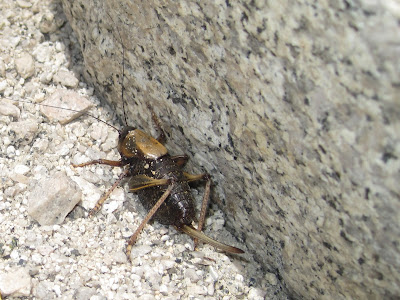
A bush cricket with its long ovipositor for laying eggs
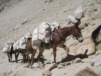
Some people cheat and have mules carry their loads. Mules also poop on the trails :(
Poor mules!
On the top of Mono Pass, and feeling good! The pass is at 12,080 feet, but is surrounded by 13,000 foot plus peaks - a very harsh environment!
On the pass is Summit Lake. Normally, there would be much more snow up here this time of the year, but this was a very dry year.
Going over the other side, and about to drop a couple thousand feet before climbing up to the Pioneer Lakes Basin later in the day.
Sue and Paul set up their spot. It was a full day of hiking to get here.
Preparing "dinner" before daylight runs out. We have vowed to get more creative with food next time, and stay away from the expensive, boring, freeze dried packets. We envied Paul's and Sue's tortillas and abundant cheese.
Paul and Sue share a moment.
Our lake in the Pioneer Lakes Basin - morning glass.
Looking away from the lake near our tent sites.
On the third day, clouds started to add interest to the sky.
On Friday, we had a decision to make. Paul had been told that one could go cross country over this ridge, drop into another lakes basin, and loop back to our trail head the next day. We realized at this point that trying to go over this ridge, and facing an equally steep downhill, would be foolish - at least for three of our party. So, we decided to backtrack and go to a remote lake we saw on the map.
We dropped back down into the forest.
A drop in elevation means milder weather, running streams, and greenery.
Time for lunch. Note Paul practicing his Tai Chi (or is he fainting from hunger?).
Gail looking right at home.
Going to splash a little water on my face.
Friday night, we camped at Needle Lake, up on a bench and beneath "The Needle".
Sue comes up for a visit.
Dramatic skylines are the norm in the Sierras.
Sue's and Paul's site, nearer the lake.
Saturday morning, we say good bye to Needle Lake, and descend back down to the trail.
This is why we were the only people at Needle Lake - no trail and steep!
Sue decided to make the climb back up Mono Pass more challenging by carrying rocks to bring back home.
Gail about to savor our last cracker - kissing it first.
Sue and her nifty "Droid".
Summit Lake, again.
Sue gives a thumbs up for the dried pineapple.
I will never eat another Clif Bar again!
Starting back down Mono Pass - the "high country".
Looking down at Ruby Lake where we spent night one.
Sue and Paul coming down the trail.
Gail has a thing for gnarly old things.
It started to rain a little on us, and we learned the next day there was a large lightning caused fire and flash floods in the region.
Looking over our shoulders at the pretty little lakes in Rock Creek.
Just about back to the trailhead. Some of the animal highlights were seeing a peregrine falcon, bald eagle, marmots, clark's nutcrackers, juncos, pikas, and chipmunks. Sunday, Gail and I spent the day at Mono Lake, about 30 miles to the north. Blog post to come soon!
Subscribe to:
Comments (Atom)


